Sierra High Route Trip Report

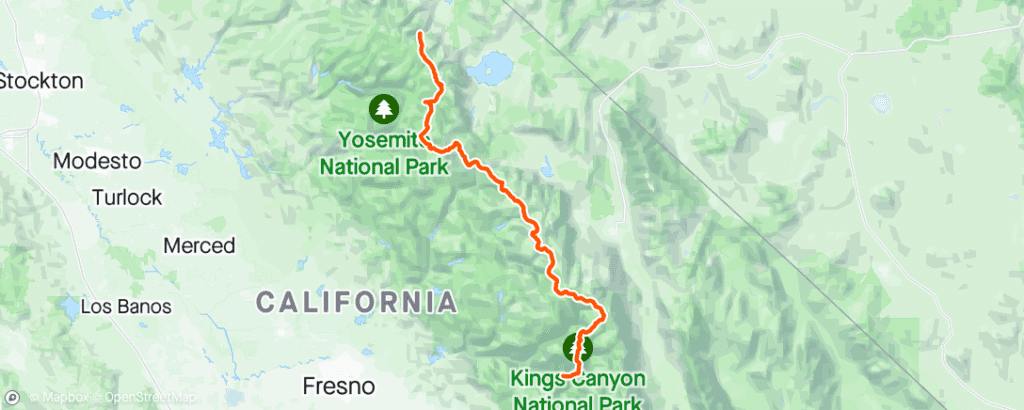
After many months of planning, researching and training I felt very fortunate to be standing at the Southern trailhead of the Sierra High Route (SHR) on July 27, 2022. Officially, the SHR traverses 314km (195 miles) along the Sierra Nevada Mountains at elevations typically between 10,000 and 12,000 feet.
The route is approximately 40% on trails and 60% off trail. When hiking the off trail portions of the route it’s not uncommon to go for days without seeing another person. This was to be my first multi-week solo hike and I was looking forward to experiencing the beauty of the Sierra’s, the solitude and the challenge of this strenuous route.
CLICK ON IMAGES TO EXPAND AND ZOOM IN

My goal was to cover the distance over the next 20 days if all went well. I would carry enough food for 12 days which would get me to Red’s Meadow, a small resort right on the route where I had previously shipped another 8 days of food to see me through the end of the hike. Many hikers will resupply more frequently but the other options are all off the route by a return distance of 32km or more. The choices were to carry less food, have a lighter pack, but add a fair bit more distance to the hike or carry more food and keep the mileage the same but start with a much heavier pack.

The biggest issue with starting with a heavier pack was that it would be at it’s heaviest while also going through the acclimation process. At 10,000-12,000 feet there is around 1/3 less oxygen so I expected the first 4 or 5 days to be tough. I wasn’t wrong.
The SHR was a big step up from previous hikes I had done in the past as the longest had been a 6 day, 135km trek on the Sunshine Coast Trail in 2021. I knew that thorough preparation was the key and the only chance I had to finish the route.
Day 1
or Choose Day Below